The bridge to Willwell Farm

I take the tram to and from Clifton pretty regularly, and the other day noticed a curious sight from the window. Between Southchurch Drive North and Ruddington Lane stops (looking to the right as the tram headed townwards) I saw what looked like Victorian brickwork semi-hidden among grass and bushes. This morning I ventured back to investigate.

The brickwork I’d spied was part of an old railway bridge. I took photographs whilst there which you can see below. I didn’t force entry anywhere, nor did I climb over or through a fence. There were no signs telling me this was private property. The land where the bridge was situated was accessible to anyone.

The bridge was grassed-over, but had recent treads from a heavy vehicle passing over it.

Willwell Farm bridge

DSC01870
Looking south on the bridge towards Southchurch Drive
DSC01869
A gas pipeline and the arches beneath the bridge
DSC01867
Looking southwards towards Ruddington from the bridge

Getting back home I went to my trusted Insight Mapping to check the location. In late Victorian/Edwardian times it had been a footbridge over the railway tracks for people travelling to and from Willwell Farm. There’s no sign of the railway track any more, but I traced them on Insight Mapping and discovered the next railway bridge south is part of Clifton Road in Ruddington. This is the bridge that used to provide access to the long-forgotten Ruddington Station.

You can also see on Insight that the modern tram tracks join-up with what used to be railway tracks on their journey toward the city. I’ve included a comparitive map showing the same spot before trams and railways cleaved through the land.

Willwell comparative map 1
The site of the bridge in 2018 on Insight Mapping. The dark grey curved line above and to the left of the arrow marks the modern tram track.
Willwell comparative map 2
The bridge marked on a map produced sometime between 1912 and 1919. Willwell Farm is marked to the east of the bridge.
Willwell comparative map 3
I remember when this was all fields! Before railways, trams and bridges.

The Slums of Victorian Nottingham: St Stephen’s

I don’t know why it’s taken me this long to discover the joy of My Maps on Google. Using a backdrop of a Google Map, it allows users to add landmarks, notations, and photographs of their own, relating to whatever topic they desire. You will know already that I’m a fan of maps, and have a compulsion to overlay old and new street plans and building outlines, and so doubtless see the attraction of My Maps for me.

I’ve started with one of my favourite historical locations in Nottingham; the slum area now occupied by Victoria Centre, and previously Victoria Station. It’s no where near complete, but I will update as and when I can in the future. Feel free to share it with anyone you feel would enjoy it.

The Beeston Brief Encounter: An eerie incident in the Eighties

I grew up on the Lenton Abbey estate in Beeston, the birthplace of Alan Sillitoe. When I was aged about 9 or 10 (in the mid 1980s), something spooky happened in a little lane in the neighbourhood.

I was walking with my mum from our house on Woodside Road to the shops on and around Beeston High Road. We had a route we often took to get there that cut through the council estate. We were on a little alley between Arden Close and Salthouse Lane, walking side by side. I heard footsteps close behind us, and ‘fell in’ behind mum to allow the person behind to pass. After several moments they still hadn’t passed, though the footsteps were still audible close behind me. I turned round to find no-one else was in the lane, and the sound stopped. I turned back to mum, who said matter-of-factly, “That often happens to me down here.”

We walked on in silence, not mentioning what had happened, and with me feeling incredibly spooked.

It’s a very short encounter, and I don’t have any theory about what exactly happened beyond these facts, or why. I don’t necessarily even think it ghostly, and am open to the idea of some freak of acoustics. This, to me at least, wouldn’t be any less fantastic than a phantom stalker.

I wonder if anyone else has experienced anything peculiar in that apparently nameless lane between Arden Close and Salthouse Lane, or if there are comparable stories from other Nottinghamshire estates. Below is a grab from Google Maps which I’ve marked to indicate roughly where the incident happened.

Arden Close map

Broadmarsh subway’s forgotten retail unit

I used the subway yesterday that connects Broadmarsh Bus Station with the Collin Street entrance to Broadmarsh Centre. As I did, I was surprised to see the metal shutter of a long-forgotten retail unit down there was half up, and the door open. I’m not a proper urbexer by any strecth of the imagination, but hate to pass-up a phot opp so  quickly nipped inside and took two snaps. My memories of the pace were hazy, so I tweeted the pictures and a few people got in touch with memories. @NigelBig and @delphscuba remember it as a newsagent, whilst @tracyf1971 thinks it was initially a cob shop, then a newsagent and sweet shop. @Cooperm4n added: ‘I seem to recall that an Asian chap who ran it sadly died in a crash on the M42 about 15 years ago.’

From the pics I guess the Broadmarsh owners store unused ‘point-of-sale’ and shop fittings in there.


20170210_145314061_ios

20170210_145259263_ios

20170210_145304065_ios

The secret saga set in Nottingham’s shadows

Several years ago, I learned of the developments in self-publishing and on-demand printing that are today fairly well-known. With decent computer skills, it’s possible to write and publish anything you wish, fact or fiction, and make it available on Google Books, Amazon and Barnes & Noble websites among others.
Readers of the blog will not be surprised to learn that I have self-published several overtly Nottingham-themed articles and even a novellette that can be purchased through Amazon. What might be less predictable, though, is an urban superhero fantasy saga I have recently completed.

A cursory glance through some of the previous blog posts will quickly reveal that I have a fascination with lost and forgotten places, and these form a backdrop to the tale in question. I have loosely described it as ‘Harry Potter in a hoodie’ when asked, and I think this is a reasonable shorthand for the story. The three books that comprimise the trilogy are Orphi and the Shadowpaths, The Shadow of the Grey Gargoyle, and Night Rise.

Nottingham city centre (and even the suburbs) feature in the saga, though in the interests of keeping things universal I have demured from giving the name. Local urban history hunters, though, will doubtless recognise the descriptions of the old subway, certain narrow streets, the multi-storey car park a short distance from the market place, and the coffee shop near the old library. Despite these familiar and commonplace settings, it’s a strange and at times quite melancholy story of ancient magic, dark secrets, and interferring adults.

I have only just launched Night Rise, which is the third and final part of the tale, and it feels very emotional for me. The end of a project can sometimes feel like a sad parting of ways. You get used to having the project around, and life without it can seem abruptly to be a little empty.

If you’re interested in reading the tale on your Kindle device or software and supporting independent Nottingham creativity, please feel free to explore the links below. If you had time to leave an Amazon review when you’ve finished reading, I’d be over the moon 🙂

Book 1: Orphi and the Shadowpaths

Book 2: The Shadow of the Grey Gargoyle

Book 3: Night Rise

The Shadowpaths website

3-orphi-covers-shrunken

Nottingham before the Ice (Centre) age

The National Ice Centre has been part of Nottingham since 2000, and for me at least it’s difficult to recall the street layout and buildings before it.

Checking a late 1940s/early 50s map of the site on Insight Mapping, it’s clear the changes were considerable.

image7


Barker Gate’s eastern end nowadays halts at the junction with Belward Street and Bellar Gate, but before the National Ice Centre’s construction it continued on another 150 or so meters to form a junction with Southwell Road and Lower Parliament Street. Here’s an image looking down modern Barker Gate taken today.

image1

And this is the view from Southwell Road, looking towards Barker Gate.

image2

The word ‘barker’ can refer to both someone who strips a tree of bark for the purposes of tanning (leather production), and also to those who tended sheep at pasture. Knowing that tanning was a popular trade in bygone Nottingham, I suspect the former is the meaning in the case of Barker Gate, but am not certain. ‘Gate’ in this case is an evolution of the word ‘gata’, which simply meant street.

After the change to Barker Gate, the most obvious change was the demolition of the old Nottingham Ice Stadium, which had occupied part of the site since 1939. You can read a Wikipedia article on the old building here.  Below I’ve put an image which overlays the old stadium position with the modern street map.

image3

Consulting our bygone map, we can also see a pub (‘PH’) that was lost when the National Ice Centre was constructed. I’ve made a red overlay showing its position on the modern map, and also took a picture this morning of that spot nowadays.

image4

image5

The pub was The Old Cricket Players. You can see a photo of the pub from 1995 on Picture The Past here. There’s a nice detail of the pub sign (also on Picture The Past) here.

You’ll also notice on the bygone map a large graveyard which occupies the southeast portion of the modern site. The Wikipedia article on the National Ice Centre states that bodies from this graveyard were exhumed during the modern construction. If there’s any ghostly activity in the southernmost portion of the current complex, we can probably blame the disturbance of this once hallowed ground.

Going back further on Insight Mapping, we can see that the first Ice Stadium (the smaller green area on the map below) was built on land previously occupied by Lomas’s Yard, Silverwood Place, and Paradise Place. Machine Street and Count Street were also lost, whilst the development of the tram and bus depot (the large, green area) meant the loss of Sun Street, Abinger Street, Patriot Street, Wassal Street, White Street, Pomfret Street, Earl Street, Carter Gate, Carter Place, Fredville Street, Water Street, Pollock Street, Kelly Court and Holland Yard among others. Stanhope Street remained in name, but was not exactly in its original location.

image6

RESEARCHING AND REBUILDING LENTON PRIORY

It’s difficult for members of our modern society to imagine the widespread importance that religion played in the lives of our forefathers. Comedian George Carlin famously dismissed God as ‘an invisible man who lives in the sky’ in 2009, and this line is often repeated by cynical modern atheists. In medieval times, Christianity that we would now consider Catholicism was the predominant creed, with worshippers considering the Pope as the ultimate earthly authority on spirituality. It was most mortal person’s desire to be admitted into Heaven once their life on Earth had concluded, and this is where organised religion held sway; it ‘knew’ what needed to be done on Earth for a person to be granted heavenly admission, and was therefore able to dictate how the population ‘should’ live.

Monks were reclusive Christians who lived a largely secluded and deeply disciplined life that would lead to acceptance in Heaven. Whilst most of the population was illiterate, British medieval monks were able not only to read, write and speak their native language, but also Latin, the language of Rome and the Pope. With their secluded lives, scrolls and books adorned with cryptic symbols, exotic spoken language, and sacred rituals, they were considered ‘closer to God’ than lay people, but frequently lived alongside lay communities, and willingly spread the ways of true Christianity. Most villagers in medieval Britain stood little chance of ever meeting the Pope, whereas local monks were more readily available. The Church seemed to model itself on the Roman Empire’s tactics; leaving a fort (in the form of a monastery, priory or abbey) in conquered lands (those than had been converted from nature worship or paganism) to ensure the defeated locals stayed ‘on message’.

In medieval Nottingham, a large and influential order of monks lived in Lenton Priory, which stood from the early 1100s until 1536. Sadly, no definitive plan or illustration of the Priory exists from medieval times, and so our physical sense of the long forgotten building (and its location) are reliant on archaeological digs in the area. Do a little research on the matter and you’ll come across the same words repeatedly; speculative, conjectural, and probable. Little is clear about the Priory’s physical structure, which I guess is why we don’t hear much about it. Let’s take a little walk around the site of the old Lenton Priory and get an idea of the lay of the land.

image-map

You can get to the site by taking the tram out to Gregory Street tram stop (1), which — confusingly — isn’t on Gregory Street, but Lenton Lane. If you walk a minute or so towards the QMC site, you’ll see the Priory Church of St Anthony (2). The ‘back’ section is thought to be constructed from blocks from Lenton Priory. The Priory Church of St Anthony is thought to be built roughly on the site of the Priory’s hospital chapel. All of the streets around St Anthony’s church allude to the Priory tradition; Old Church Street, Priory Street, Friar Street, the Friary, Nazareth Court, Nazareth Road, Cloister Street, Abbey Bridge.

image-priory-church

More building material rumoured to be from Lenton Priory can be seen on actual Gregory Street (3). The garden walls of number 18a (Rose Cottage) contain a top layer of red bricks but a lower layer of variably-sized rocks, rumoured to have once formed the Priory walls.

image-18a-gregory-street

The River Leen wends its way and forms a southern border to the site, and this is thought to be significant to the Priory. In the days before domestic plumbing, a natural source of running water was essential to everyday life, so it’s reasonable to think the large Priory may have been built here to utilise the river. One Priory outhouse was thought to bridge the Leen, and is assumed to have been the monk’s communal lavatory! On Priory Street is the Boat Inn (4). I like to think this may mark the location of a jetty or mooring for the monks, but in truth I suppose any pub near a waterway is likely to have a multitude of reasons for adopting the name.

Further along Priory Street is a fenced-off area (5) containing the base of a column that once supported the structure of the Priory. The column base was unearthed during excavations by William Stretton, architect and antiquarian, in 1885, but is not thought to be in its original location. In Holy Trinity Church (NG7 2FF) you can see the original font that once sat within Lenton Priory.

I found a speculative/conjectural/probable footprint of the Priory online, and using Trimble’s Sketchup software, created a speculative/conjectural/probable model of the building. I emailed Doctor Chris Brooke at the University of Nottingham’s Department of History to get an idea of what each area was likely to have been. The photographic textures and features (such as windows, doors, shutters and the like) are from the superb Textures.com, a site that should be of interest to anyone interested in digital modelling.

There are more knowledgable local historians than me, more authoritative experts in religious architecture, and better digital modellers, but I hope my representation of Nottingham’s long-forgotten Lenton Priory is interesting for you.

image-lenton-priory

Slumming it: A short walk around the Glasshouse Street slum yards

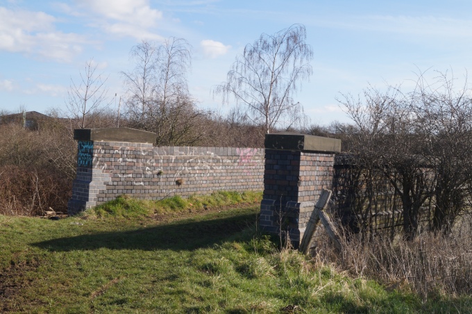
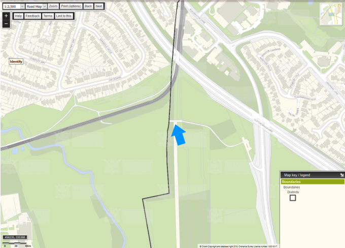
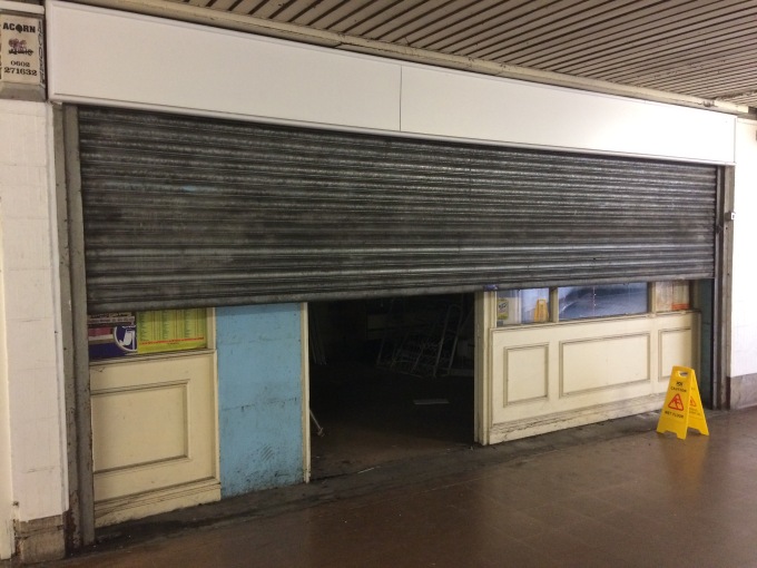
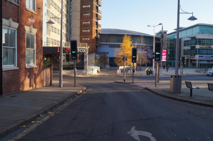
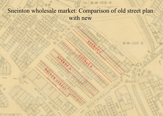
It’s hard to find a lot of in-depth information about Glasshouse Street when researching local history, though it crops-up quite a bit in the supporting cast in other location’s tales. It gets mentioned in relation to ‘The Charlotte Street area’, a slum that used to sit immediately to the west of Glasshouse Street. It’s also heard of in discussions regarding Victoria Station, which replaced the Charlotte Street area. Central Road (later Union Road) and a public footpath passed over the platforms and tracks of the station, connecting Milton Street and Glasshouse Street. The building of the station also diverted Glasshouse Street somewhat, causing it to curve abruptly north-eastwards and connect with Huntingdon Street, when it previously ambled north-west, eventually adjoining York Street (another under-appreciated thoroughfare). It modern times, Glasshouse Street grants access to Victoria Centre’s underground car park, and also hosts a pedestrian entrance to the centre for people approaching from St Ann’s. The modern situation illustrates Glasshouse Street’s problem neatly; you utilise it, but it would rarely be your destination in itself. This situation is a shame, since amateur urban history hunters can find much of interest in and around Glasshouse Street. All of the streets to the east of Glasshouse Street were punctuated with little alleyways and yards, a common feature of poorer Victoria urban areas. Let’s take a short walk beginning at the junction with Lower Parliament Street, to understand the location of such yards.

glasshouse-st-new

The southern end of Glasshouse Street is best viewed from the junction of Broad Street and Lower Parliament Street. Look to the right of Glasshouse Street at the brown brick buildings. On this site, and stretching all the way to Convent Street sat a large prison complex also incorporating a police and fire station (1800s-1912). This was replaced by the Empress Picture theatre (1912-1928) and then the Central Market (1928-early 1970s). When Victoria Centre was completed, the traders who occupied Central Market were rehoused within the new complex and the old one demolished. Those that still trade on Victoria Centre’s upper floor are the remnants of the old Central Market community.

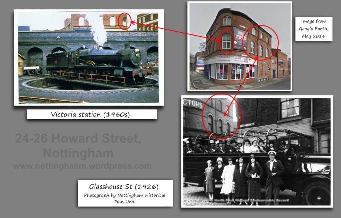
The old gas showroom building (43-55 Lower Parliament Street, circa 1920) marks the western side of Glasshouse Street’s southern entrance. It’s hard to imagine a time when simple gas fires aroused enough excitement in the populace that they required such a grand building to showcase them, but apparently this was the case. That building has remained empty and in limbo for many years now, allegedly caught in the bureaucratic vortex of Victoria Centre’s redevelopment. The same can be said of the neighbouring TN Parr buildings. TN Parr was a pork butcher and pie crafter extraordinaire (with three sites around the city centre as well as a base on Lilac Grove in Beeston) who owned the buildings between 1874 and 1928. The Parr family were big players in the pork pie market, since Ken Parr (nephew of TN Parr) started Pork Farms, which TN Parr (the business, not the individual) bought-out in 1969. I like to imagine that Parr family gatherings were somewhat akin to an episode of Dallas, but with pork jelly instead of oil causing tension between different factions.

tnparr

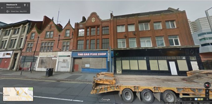
The wonderful row of buildings has hosted a varied array of businesses over the years, including Broughton Locksmiths in the late 1990s. A peeling sign above one doorway indicates that it was once home to the intriguing-sounding Central Investigation Service, whilst the sign of the neighbouring property shows that it was the Gas Fire Shop. Clearly this part of Nottingham was the place to go for the discerning gas fire enthusiast. I’m sure as a sometimes-inebreated youth in the 1990s I used to stumble into a kebab shop that was part of the buildings. They are boarded-up at the moment, and a notice posted on them last year stated they were due for demolition in April 2015, again as part of Victoria Centre’s redevelopment. I asked owners Intu if I could go inside to make a photographic record of the buildings after glimpsing this sign, and they stated they’d look into it but sadly never got back to me. The Parr buildings seem to have a stay of execution, though, and remain for the time being. You can get a lovely view of their ramshackle rears via Clare Street.
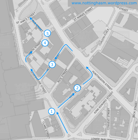
(1) UNION PLACE

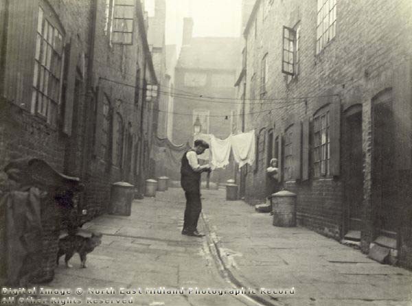
On the west side of Glasshouse Street, behind Central Buildings (adjoining the Parr building) once sat Union Place, the first of today’s slum yards. Union Place is mirrored somewhat in the modern space used for deliveries to Argos on Parliament Street, though the old site would have been cramped and overcrowded. Many people seem unaware that you can cut the corner by going across this area and through the little gate onto Clare Street. We’re headed in the opposite direction, though, so turn back around and let’s continue with the tour.

ntgm002403-union-place

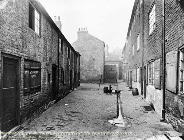
ABOVE: Union Place in the early 1900s. Image from Picture The Past.
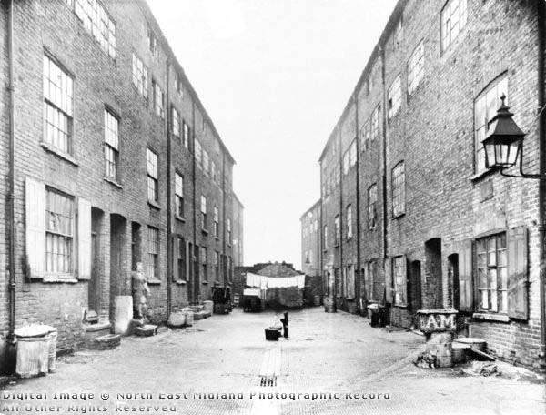
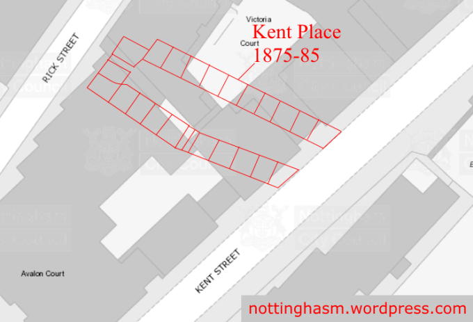
(2) KENT PLACE

At the junction, turn onto Kent Street, then pause when the entrance to Victoria Court is on you left. Turn back to face north-west, and you’ll be more-or-less looking upon what was once the entrance to Kent Place.

victoria-court

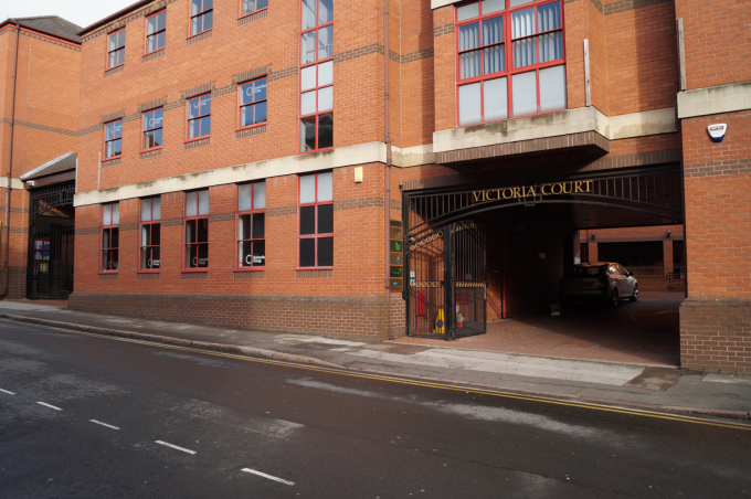
ABOVE: The entrance to Victoria Court in 2016. The entrance to Kent Place overlapped somewhat with this site. BELOW: Kent Place shown in red on a modern map.
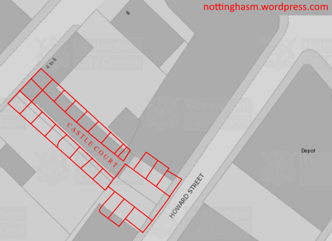
kent-place

(3) CASTLE COURT

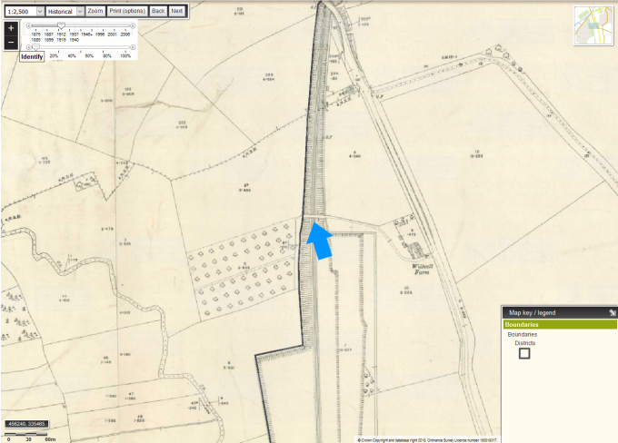
Keep walking west down Kent Street, then take a left onto Huntingdon Street. Keep walking until you spot Howard Street on your left, and walk up this thoroughfare back towards Glasshouse Street. About two thirds of the way up, to your right, is the site that was once the entrance to Castle Court, another of the neighbourhood’s residential yards.

ntgm012934-castle-court

ABOVE: Castle Court around 1932. Image from Picture The Past. BELOW: A map overlay showing the site of Castle Court over a 2016 map.
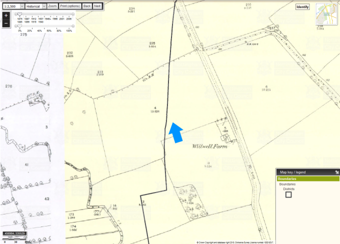
castle-court

(4) MILK SQUARE

At the top of Howard Street, take a right onto Glasshouse Street then another right onto what is now Perth Street. In days gone by, this was called Milk Street. On your right about a third of the way down would have been the back of Castle Court, and a short distance further (still looking right) was where Milk Square stood.

ntgm008621-milk-square

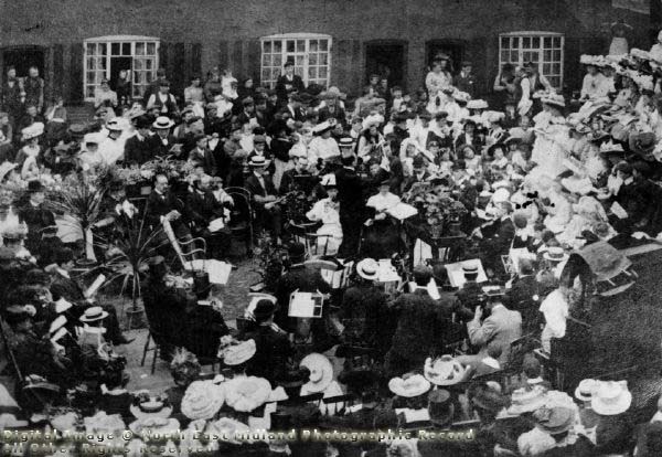
ABOVE: The Orchestra of Circus Street Hall Men’s Sunday Morning Institute playing in Milk Square for the Sunday School in celebration of the anniversary of the Milk Square Mission. Image from Picture The Past.

(5) APPLE ROW

At the bottom of Perth Street was the entrance to Apple Row. Turn left onto Old Street (which was called Old Street even in Georgian times, so could now possibly be considered Really Old Street), and on your right you’ll be passing the site of an unnamed alley that provided an alternate way in and out of Apple Row.

ntgm012530-apple-row

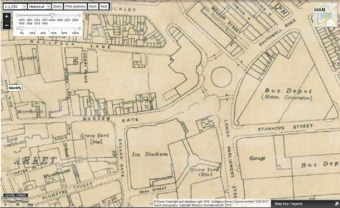
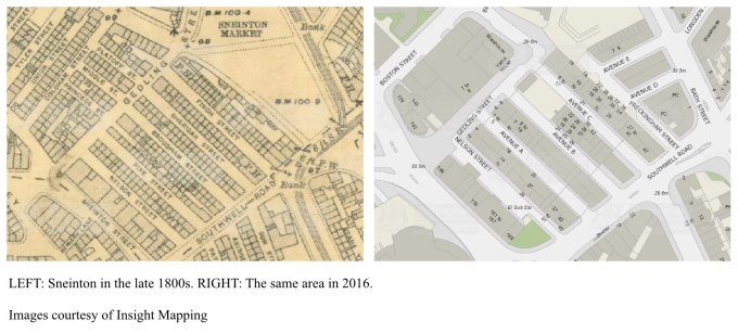
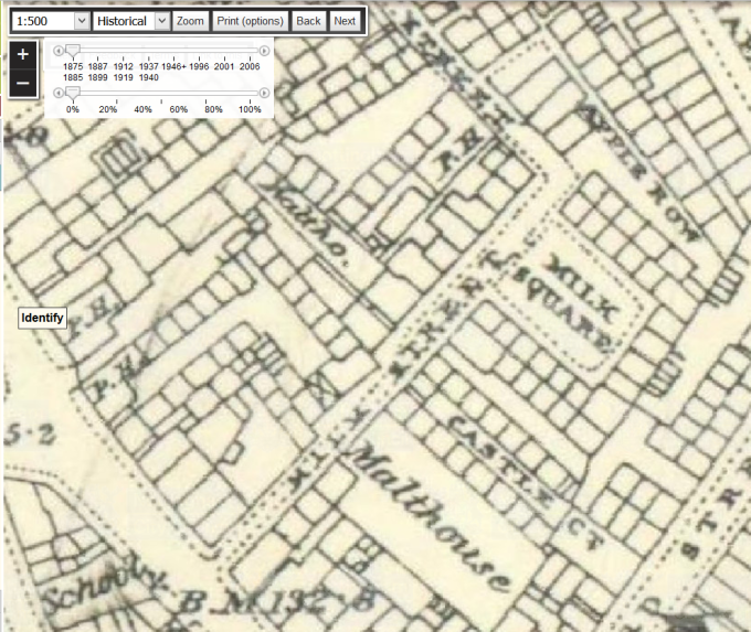
ABOVE: Apple Row circa 1912. BELOW: A close-up of the 1875-85 map from Insight Mapping,  showing Milk Street (diagonally through the centre), Castle Court, Milk Square and Apple Row.

glasshouse-st-map

On St Ann’s Street, take a left and admire the facade (and — if you’re thirsty — the interior!) of the LGBT-friendly New Forester’s Inn. At the corner of Glasshouse Street, you’ll have a good view of Victorian boozer The White Hart Inn, a pub and hotel. It was renamed The Owd Boots in 1983, when it began to attract a leather-clad rock crowd. The large premises have since been split into separate units, the north-most section trading until recently as a cafe, the middle section as a pub, and the southern portion as a barber. Just south of this building you can see the coach house, stable and hayloft that once serviced the Victorian premises.

This is a very short walk around an area that in days gone by would have been smelly, noisy, and unhygienic. Such locations are lamented, but it’s worth noting that Nottingham would have been unlikely to achieve its prosperity and city status if not for the slum areas. As squalid as they became, such areas housed the thousands who flocked here to work in the booming textiles industry. The workers needed somewhere to live, but let’s not forget that the city’s entrepreneurs desperately needed those workers, too. Without the huddled, slum-dwelling masses to churn-out the lace for them, the businessmen would have had nothing to sell.

Doing the ABC in Sneinton’s old wholesale market

Sneinton’s old wholsesale market is a curious collection of buildings dating from the late 1930s. In days gone by, retailers in the city visited Sneinton to stock-up on fruit and veg, fish, eggs, flowers and sundries to sell in their stores. The market moved to an area just off Meadow Lane, and the original site has been deserted (and rather ramshackle) for years. However, it has now been renovated by the council, and has units up for rent.

swm-google
The main streets of the wholesale market are named Avenues A, B, C, D and E. Comparing an Edwardian map of the area (courtesy of Insight Mapping) with the modern site, I was quite saddened to see that the streets demolished to make way for the wholesale market had much more interesting names; Pipe Street, Lucknow Street, Brougham Street, Sheridan Street and Finch Street all made way for the market buildings in (or perhaps just before) 1938. The Avenues don’t match the location of these residential streets exactly, but are pretty close. It’s interesting to see that the Fox & Grapes public house (nicknamed Pretty Windows, and later renamed Peggers) was built on the site of an earlier pub that dates from at least the late 1800s. The name of the Pretty Windows Day Nursery that is based on Avenue A is a reference to the tavern, though the striking panes are no longer visible on the deserted pub building.

swm-side-by-side

swm-overlay

Freckingham Street (shown in the Google image at the top of the post) is named after the Alderman who opened the wholesale market in 1938, and I wonder if Pipe, Lucknow, Brougham, Sheridan and Finch were similar figures from an earlier time. It’s sad when a street’s lost and replaced with something as impersonal as Avenue A. Although we mightn’t know (or care) why a street is named Lucknow Street (for example), there’s no denying it is more characterful than simply being assigned a  letter.

Those lost streets were demolished as part of the city’s bid to clear the slum housing and modernise the city. People nowadays often mourn the disappearance of such neighbourhoods, but in truth we couldn’t keep them. They were structurally unsound, unhygenic and degrading to live in. I think what people really mean when they say they wish those buildings remained is just that they’d be curious to see them, or would like to travel back in time to see them. Photographs will have to suffice nowadays, and we’re lucky that in Nottingham we have Picture The Past to consult on such matters. If you click here you’ll see a picture of long-forgotten Pipe Street, Sneinton courtesy of Picture The Past.

24-26 Howard Street

Glasshouse Street and its offshoots get short shrift from local history resources generally. The site is frequently mentioned as an aside, but rarely discussed on its own merits. Always one for an underdog, I therefore peruse the locale regularly, both in person and in terms of online research.

At the junction with Howard Street there is a wonderful Victorian building (officially 24-26 Howard Street) that always catches my eye. I love the brickwork over the windows, and the soot and grime on the bricks on the upper levels. I imagine some of this would have been from steam blown out of engines passing through Victoria Station. The businesses housed within it change fairly regularly. I remember buying balloons from a party shop there in the early 2000s, and it now seems to be a beauty salon. There seems to be a residential element nowadays, with some doors and letterboxes on Glasshouse Street itself.

In the hours I’ve spent looking through old photographs of Nottingham, this building has cropped-up a number of times, standing in the background like a silent sentinel overseeing the many changes around it. I bought a colour photograph from eBay of an engine being manoeuvred on a turntable in Victoria Station circa 1960, and sure enough my old pal 24-26 Howard Street was visible at street level in the background. In researching Glasshouse Street generally, I chanced upon an image from Picture The Past of several women enjoying an outing in a charabanc, and they had — of course — paused just by the building for a quick photoshoot. I’ll be mortified if it ever gets knocked down.

I’m in the process of assembling info on Glasshouse Street and its surrounds for a longer post, but thought I’d whet your appetite with this little appreciation of a long-overlooked artifact of yesteryear.

Howard Street